Saturday May 2, 2026 Hike Summary

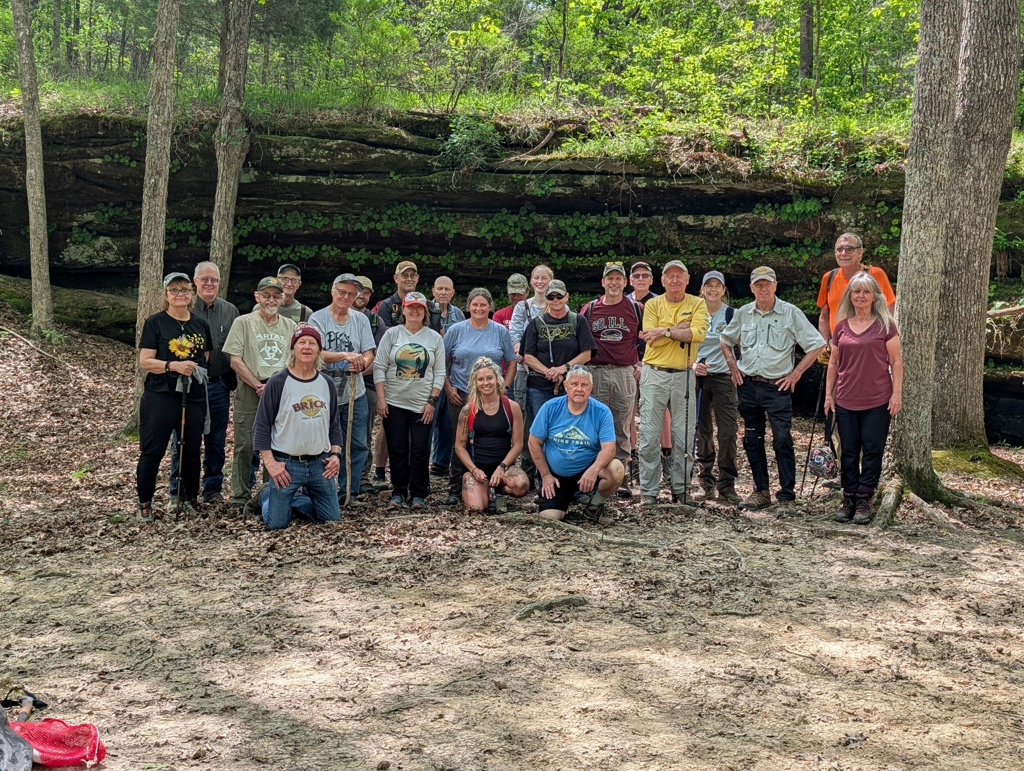
For todays’ hike, we gathered at a curve on a gravel road…on Bowman Bottoms Road. We weren’t ‘in the bottoms” tho. Megan Henderson led 14 hikers, none of which were “new” to the Society. We headed off South along a power line cut, then turned east into the woods, to find the “rabbit hole” a place where you start on top, bend over and crawl thru a cavity, probably created by running water eons ago, and end up coming out a few feet lower. Some also wandered along a bluff wall…to another “crawl thru” area. Along that stretch, we also found some graffiti. 

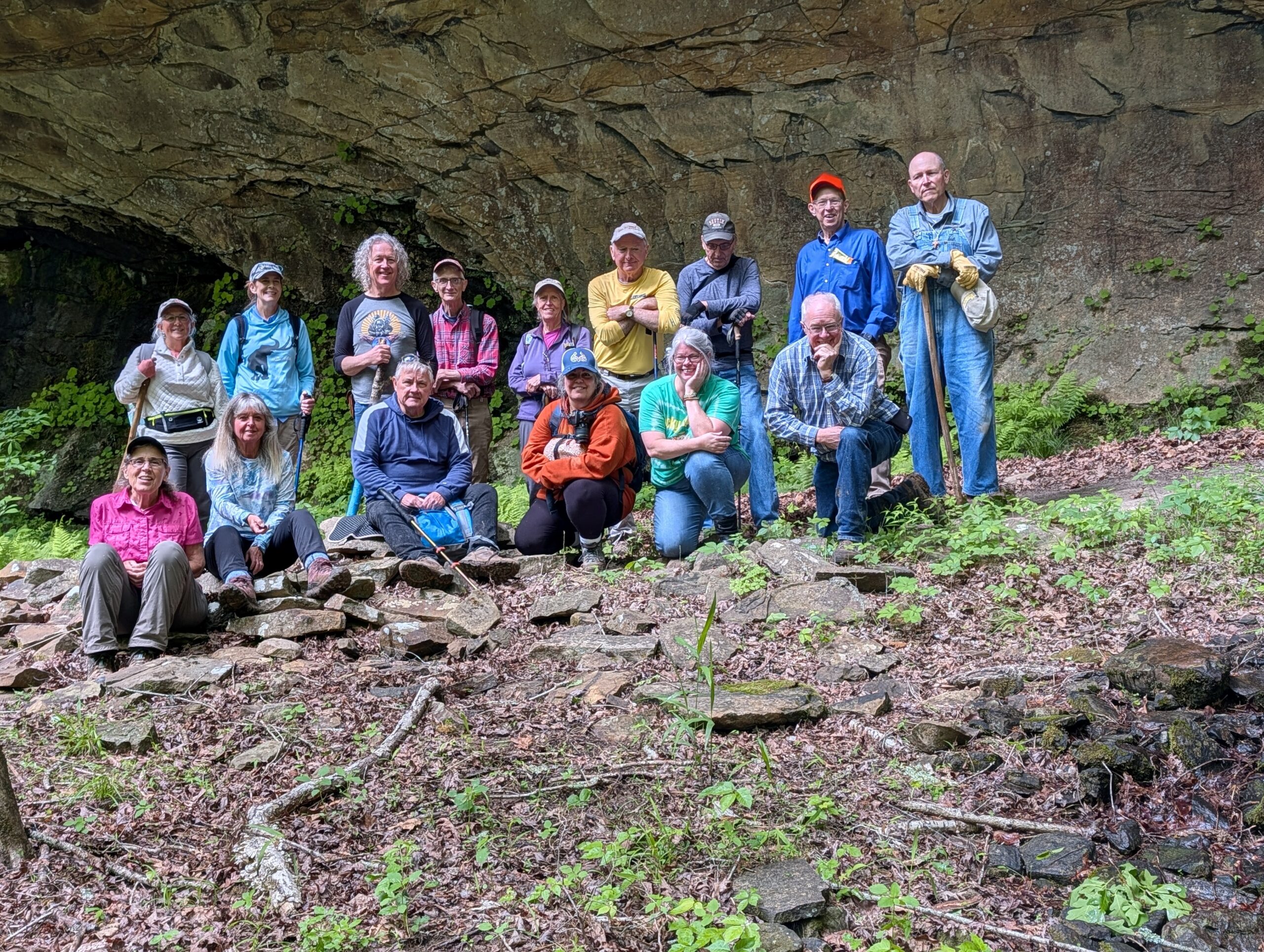
Next, we headed back out to the power line cut, cut across it to the west side, and worked our way South thru the woods. Megan had told us that most of the day would not be on a trail. We ended up following a small stream, heading west…and Then…we found the Schwegman Sentinels. About 4, Large , independent Rocks, spaced 30-50 feet apart, all in pretty much of a line. After we all climbed up to them, and around them, we continued following the creek, , made a few turns, and then came upon a large bluff line, with a big overhang, shelter bluff. We ate lunch there, took the group picture, and ended up going past them and getting up “on top” of the shelter bluff. By then, there were distant sounds of thunder, skies to the North were getting darker, and, cell phone signal coverage was good enough, that we made the decision we needed to move quickly towards the vehicles. We got out juuuuust as it began to rain. Megan had planned to go to Bulge Hole to look for possible water falls, but, alas, another time. We ended up hiking about 3 miles. 

Next weeks’ hike, on Saturday May 9th,  the Last of the Spring 2026 season, will be led by Bob Mulcahy, in Alexander county, meeting at the Horse Creek trail head, east of McClure. 

Until then, “See ya’ll On the Trail”. 

Saturday April 25, 2026 Hike Summary

The skies were bright blue, with a few puffy white clouds and the forest greenery was showing as Carl Brannan led 23 hikers from our meeting spot on Stone Bottom road, down trail 481. We even had 3 new hikers. Most had “sprayed down” with some form of tick repellant” because the temps were “ripe” for ticks. We still, though, were in a dry spell of weather. The dry spell was fully evident with about any stream we crossed either dry or maybe a few dribbles of water. We headed to Upper and Lower Salt Peter cave and there we crossed Lusk Creek for the 1st time. It somehow, did have some flow, although a very few might have gotten a foot wet, slipping on the rocks as they crossed. We wound around, were “on top’ of the Natural Bridge, then ate lunch and took the group picture at the lower part of the Natural bridge as the backdrop. After lunch break, we headed out to Secret Canyon, and took a bit of a break there. We did see several small groups of equestrian riders during the day. We saw lots of older work done by horse groups along the trails..the “turnpikes”…logs laid along the trail, with gravel between the logs. All total, we hiked over 8 miles today. We saw very little trash, picked up what we did see and of course, took it out with us. 

Next weeks’ hike, on May 2nd, will be meeting at Bowman Bottoms road, with a good amount of the hike being “off trail”, with several stream crossings. 

Until then, “See ya’ll On the Trail” 

Saturday, May 2, 2026 Hike Announcement

The River to River Trail Society announces its 9th public hike of the 2026 Spring hiking season on May 2nd.  Hiking: Bulge Hole/Schwegman Ecological Area (Johnson County). This hike is free and open to the public. This will be a moderately difficult hike off trail including several stream crossings, approximately 4.5 miles in length, 3-4 hours hiking time. The leader of this hike can be reached at 618-967-0019 for more information. Hikers should meet at 10:00 am at Bowman Bottoms Rd. This hike is intended for people in very good health who have done some hiking. Hiking sticks and boots or sturdy shoes are recommended. Hikers should bring their own water and snacks. No dogs, please. Check the post on the River to River Trail Society website www.rivertorivertrail.net for this current week’s hike information including driving directions. For a map to the meeting location on Bowman Bottoms Road click this blue link. A map will open up, click the Directions button and a driving map will be created which will allow you to plan your driving directions to the meeting area. Prior to participating in any hikes, the River to River Trail Society requests that all hikers read the 2023 Trail Society Waiver which can be found on the River to River website at the following link https://rivertorivertrail.net/ under the Society Information tab. The waiver will be at the beginning of the hike.

Saturday April 18, 2026 Hike Summary

It was a rainy Saturday morning, but, 11 hardy hikers braved the showers to meet at a shelter at Dixon Springs State Park.  We had all looked at the radar maps on our phones, and felt like the rain would soon pass. We took the group picture first, and then Fred Scott, our leader for the day, led us out east along some wide pine-needle covered trails. We soon turned North and crossed a few streams. The rain showers  quit and the temps dropped slightly. We had just enough rain to make a few waterfalls trickle. We did have 2 new hikers with us, 1 of which was a journalism student at SIU-C that worked for the Daily Egyptian. We saw a bit of everything on todays’ hike…a few stream crossings, some rock formations with a dribbling waterfall or 2,  a “walk in the woods’ and several large areas of sandstone glades…exposed areas of rock. Fred did an interesting “mix” of areas and trails. We stopped to eat lunch at 1 glade area, then headed back towards the parking area. This was a good, longer “loop” hike. We ended up covering about 5.5 miles. 

  The hike this coming week will be in the Lusk Creek area, led by Carl Brannan. 

Until then, “See ya’ll On the Trail” 

Saturday, April 25, 2026 Hike Announcement

The River to River Trail Society announces its 8th public hike of the 2026 Spring hiking season on April 25th.  Hiking: Lusk Creek, Salt Peter Cave, Natural Bridge, Secret Canyon (Pope County). This hike is free and open to the public. This will be a moderately difficult hike including several stream crossings, approximately 8 miles in length, 4.5 hours hiking time. The leader of this hike can be reached at 618-663-0384 for more information. Hikers should meet at 10:00 am at Stone Bottoms Rd. This hike is intended for people in very good health who have done some hiking. Hiking sticks and boots or sturdy shoes are recommended. Hikers should bring their own water and snacks. No dogs, please. Check the post on the River to River Trail Society website www.rivertorivertrail.net for this current week’s hike information including driving directions to the meeting area for this week’s hike. For a map to the meeting location on Stone Bottoms Road click this blue link. A map will open up, click the Directions button and a driving map will be created which will allow you to plan your driving directions to the meeting area. Prior to participating in any hikes, the River to River Trail Society requests that all hikers read the 2023 Trail Society Waiver which can be found on the River to River website at the following link  https://rivertorivertrail.net/ under the Society Information tab. The waiver will be at the beginning of the hike for signature.

Saturday, April 11, 2026 Hike Announcement

The River to River Trail Society announces its 6th public hike of the 2026 Spring hiking season on April 11th  Hiking: Wild Turkey Trail (Williamson County). This hike is free and open to the public. It will have a proliferation of wildflowers this time of year. This will be a moderate in and out lollipop hike approximately 4.6 miles in length approximately 3-4 hours hiking time. The leader of this hike can be reached at 618-759-1924 for more information. Hikers should meet at 10:00 am at the Wild Turkey Trailhead. This hike is intended for people in very good health who have done some hiking. Hiking sticks and boots or sturdy shoes are recommended. Hikers should bring their own water and snacks. No dogs please. There are stream crossings which will require hikers to walk rocks and or slick rock in order to cross the streams and the rocks may be slippery. We have limited parking, park up the hill to the left, This hike may be tracked using the Avenza App. map to use, SNF Crab Orchard Lake Quad map. For a map to the meeting location at the Wild Turkey Trailhead click this blue link Wild Turkey Trailhead  and a map will open up, and then click the Directions button and a driving map will be created which will allow you to plan your driving directions to the meeting area. Prior to participating in any hikes, the River to River Trail Society requests that all hikers read the 2023 Trail Society Waiver which can be found on the River to River website at the following link River to River Trail Society Information and then sign off on this waiver prior to the beginning of the hike. A copy of the waiver will be at the Wild Turkey Trailhead meeting area for your signature. Parking passes are required for this hike. A Crab Orchard parking pass is required for this hike and can be purchased via the internet from Recreation.gov. An America The Beautiful Pass will also work as a parking pass.

Saturday March 28, 2026 Hike Summary

It was a bright, clear, sunny, with a bit of wind, Saturday morning that 23 hikers gathered at the parking lot of New Simpson-Tunnel Hill school to be led by Sam Morales. We had several new to the Society hikers. We loaded into vehicles and moved out to the Gum Springs trailhead parking lot. Sam led us up the River to River trail, then “Y’ed” off to the left. I had not observed as many daffodil patches ever before along the old road bed that we climbed. We crossed a small stream, then went to the bottom of Easter basket falls. It was, at least, dribbling. We then hiked around, ate lunch and took the group picture at the Easter Basket. We moved out down the trail, then did some “bush-wacking” to hook up with trail 154, then back to where we “Y-ed” off, then back to the parking area. We ended up with just over 5 miles. 

Next weeks’ hike will be the Crest Trail hike, led by Chris Drone. It will be about 6 miles,  Meeting at the Tecumseh statue, at the West end of the drive on the upper drive of Glen. O. Jones lake, in Saline county. We will hike over to the Stoneface parking lot. 

Until then, “See ya’ll On the Trail “. 

Saturday, April 4, 2026 Hike Announcement

The River to River Trail Society announces it 5th public hike of the 2026 Spring hiking season on April 4th.  Hiking: Crest Trail, (Saline County). This hike is free and open to the public. This will be a moderate, hike approximately 6.5 miles in length from Tecumseh statue at the top of Glen O. Jones Lake, over to Stoneface. Few streams. Hiking time is 4 hours plus shuttle back to parking area. The leader of this hike can be reached at 618-926-3250 for more information. Hikers should meet at 10:00 am at the Tecumseh Statue. This hike is intended for people in very good health who have done some hiking. Hiking sticks and boots or sturdy shoes are recommended. Hikers should bring their own water and snacks. No dogs, please.  Potential hikers can download an Avenza Map of this hike from this page https://rivertorivertrail.net/home/other-snf-info/other-shawnee-maps-for-the-avenza-app/ Check the post on the River to River Trail Society website www.rivertorivertrail.net for the current week’s hike information including driving directions to the meeting area. For a map to the meeting location, click this blue link: Crest Trail, a map will open up, click the Directions button and a driving map will be created which will allow you to plan your driving directions to the meeting area. Prior to participating in any hikes, the River to River Trail Society requests that all hikers read the 2023 Trail Society Waiver which can be found on the River to River Trail Society website at the following link https://rivertorivertrail.net/ under the Society Information tab. The waiver will be at the meeting place for your signature.

Saturday March 21, 2026 Hike Summary

On a Well Above normal temperature Saturday morning, Melanie Kasson led a total of 20 other hikers on about a 7 mile hike in and around Ferne Clyffe state park.  3 new hikers joined  us today. We met at the main parking area for the waterfall and headed straight Up the Boy Scout trail. We did “pick up” 1 of the hikers at the top of the trail. We went South down the street for just a few yards, and headed back into the woods. We were on wide, easy lanes to start with…part of the River to River trail then to Happy Hollow trail, and ate lunch and took the group picture at the Lake View shelter. After lunch , we took the Round Bluff nature preserve trail, came by the Lake view shelter again, hit part of the Lake trail, crossed the road, and took the Black Jack Oak trail back to the main parking area. It was a warm, but, gooood day. 

Next week, we will gather, usual time of 10am  at the New Simpson/Tunnel Hill school parking lot on Rt. 45, across the highway from the Dollar General store, to be led by Sam Morales. We will probably carpool somewhat to the start of the hike. 

Saturday, March 28, 2026 Hike Announcement

The River to River Trail Society announces its 4th public hike of the 2026 Spring hiking season on March 28th.  Hiking: Easter Basket Arch, (Johnson County). This hike is free and open to the public. This will be a moderate, loop hike approximately 5.4 miles in length with 0.10 miles of bushwhacking and a stream crossing. Total time is 4.5 hours including shuttle to the actual hiking area. The leader of this hike can be reached at 618-384-1321 for more information. Hikers should meet at 10:00 am at the New Simpson Hill SD 32 School. This hike is intended for people in very good health who have done some hiking. Hiking sticks and boots or sturdy shoes are recommended. Hikers should bring their own water and snacks. No dogs, please.  Check the post on the River to River Trail Society website www.rivertorivertrail.net for the current week’s hike information including driving directions to the meeting area. For a map to the meeting location, click this blue link: New Simpson Hill SD 32 School. A map will open up, click the Directions button and a driving map will be created which will allow you to plan your driving directions to the meeting area. Prior to participating in any hikes, the River to River Trail Society requests that all hikers read the 2023 Trail Society Waiver which can be found on the River to River Trail Society website at the following link https://rivertorivertrail.net/ under the Society Information tab. The waiver will be at the meeting place for your signature.