Dutchman Lake Reroute Construction Starts
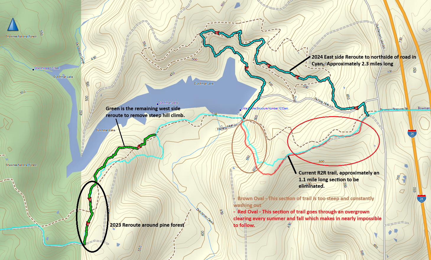
On October 29, 2024, the Forest Service trail crew started construction of the River to River (R2R) Trail reroute in the Dutchman Lake area. This reroute is a continuation of the reroute that was started in February 2023 when a 1/2 mile section of the trail west of the lake was rerouted around the pine forest section. The Trail Society and Forest Service have been working on this reroute for several years now. The following image is a map of the area showing the work plan.

Work started at Dutchman Lake Road heading west. The future trail will cross Fishing Hole Lane and meander it way around the bluffs and waterfalls to slowly descend down the hill toward the dam. Most of the route follows many of the existing user made trails the area. This reroute will affect existing maps 15 & 16 in the R2R Trail bundle if your are using Avenza and chapter 10 of the Trail Guide. When complete, the reroute will add about 1.2 miles to the length of the R2R trail through the area.
The concerns that prompted this complete reroute include the following:
- For the first 1/2 mile east of Twinz Lane on the west side of the area was reroute the pine forest because the pines started falling because they were getting too old. The problem started back in 2018/2019 when upwards of 70+ trees fell requiring a significant work days in November 2019 to clear the trail. More trees continued to fall in the following years and due to the lack of a tree canopy the trail became impassable due to overgrown weeds. In late 2022 the Forest Service agreed a reroute was necessary and that work was completed on a Society work day in February 2023. See black oval in map above.
- For the first 3/4 mile east of fishing hole lane, the existing trail traveled through a 100′ wide clearing between pine forests on each side. In this clearing area the trail would get extremely overgrown with weeds in the summer and early fall to the point that the trail could not be followed. Also, in recent years there have been several pines that have started falling over that section of trail requiring numerous work days to clear them. See the red oval in the map above.
- The last to problem areas are where the trail is too steep to meet FS standards. These steep sections of trail are subject to constant erosion problems which has been occurring for years. One of these areas is shown in the brown oval in the above map. The second area is where the trail goes back uphill after crossing the dam.
Trail maps 15 & 16 will be officially reissued once construction is complete and the blue “i” trail assurance markers are installed along the new route and markers removed from the existing route. Similarly, an update to the Trail Guide will be issued to include this reroute and the Cedar Lake Reroute completed during the summer of 2024.

Trail work started with the dozer working along the trail to clear the route and install drainages.

Following behind the dozer is a mini excavator that fine tunes the trail and drainages.